
“As though the New Jersey suburbs were grafted onto South Carolina” is how Robert Lang of Virginia Tech’s Metropolitan Institute described Northern Virginia. Of course that’s a bit of a hyperbole. Even at the time of the Civil War, Virginia was one of the least “Southern” members of the Confederacy. Today, the entire state bears the marks of a massive post-1960’s influx of migrants from other parts of the country, while other regions have also developed their own character. But Northern Virginia continues to be one of the most unique (and economically important) areas of the Commonwealth.
Mapping a region is difficult and controversial. Recently Aaron Renn posted about 12 ways to map the Midwest. FiveThirtyEight took a look at which states are in the South. Working in the same vein, I’d like to look at several ways to map “Northern Virginia.”
1. Lord Fairfax’s land grant
Northern Virginia as a distinct region actually predates the founding of Washington, DC. In 1649, Charles II (then in exile) gave all the land between the Rappahannock and the Potomac to seven Englishmen who had supported him faithfully during the English Civil War.

Lord Culpeper eventually gained 5/6th of the shares of the grant, which he passed to his daughter, who married Lord Fairfax in 1690. Lord Fairfax bought out the final share from Baron Arlington (lots of familiar names here) and the grant was consolidated under his name. Throughout the colonial era, the grant caused problems between Lord Fairfax and the House of Burgesses in Williamsburg. The ability to grant property and collect fees was a significant source of revenue and authority at the time. Lord Fairfax successfully preserved his claim over the grant against the claims of the House of Burgesses. Land ownership records for northern Virginia were maintained in a separate land office up until the Civil War, when they were finally consolidated in Richmond. Fairfax’s control meant that a very different group of settlers were able to get pieces of Northern Virginia than those who went through the colony government further south.

2. The Union
At the outbreak of the Civil War, most of the delegates from Fairfax Grant counties voted against the initial motion to secede from the Union, which failed on April 4th, 1861 (North Carolina had rejected a similar motion weeks earlier). Eleven days later, however, South Carolina troops fired on Fort Sumter and Lincoln called for troops from every remaining state to suppress the rebellion. Unwilling to be part of a war against other Southerners, many delegates flipped their votes and the motion to secede passed on April 17th (North Carolina followed suit soon after). Among the delegates who maintained their vote against secession even after Lincoln’s call for troops were those from Fairfax, Loudoun, and Frederick Counties:
Much of what is now Northern Virginia remained under Union influence throughout the war, with the Union-recognized “Restored Government of Virginia” headquartered in Alexandria after 1863.
3. Urbanization
Today Northern Virginia is known less for its role in the Civil War and more for its relationship to Washington, DC, and the urbanized Northeast corridor stretching from Boston all the way down to Fredericksburg:

The Boston-Washington corridor remains the nation’s largest economic engine and is home to 1/6th of the country’s population. The increasing economic integration of the mid-Atlantic cities is visible in all sorts of maps, including this fascinating map of the travels of dollar bills. By mapping the movement of currency, Dirk Brockmann was able to trace the invisible lines that bills don’t tend to cross and gave us a picture of the “effective communities” in the United States. Virginia is in an interesting transitional zone between the Northeast and the Carolinas, but there is a clear line running along the Rappahannock River:

4. Jobs
The economic influence of the DC metro area can be seen a long way away in the DC exurbs. “Exurbs” are places that continue to look rural, but are really bedroom communities for workers commuting into the DC area, which is packed with high-paying jobs. The most recently available commuting data that includes Federal employees comes from the 2006-2010 Census Transportation Planning Product, making this map a bit dated, but it shows the extent of the neighborhoods and towns connected to the DC metro area by commuters. When more than 10% of workers in a town are commuting into a nearby metro area, the wealth generated by that metro area is probably a strong piece of the town’s economic base.

5. Money
Speaking of economic power, the Northern Virginia suburbs of DC are not just the wealthiest counties in the state; they pack the list of the wealthiest counties in the entire country. There are certainly affluent enclaves in all of the state’s metro areas, particularly Richmond’s West End, Ivy and Keswick outside Charlottesville, parts of Chesapeake and James City County, and around the bays and creeks of the Lynnhaven Inlet in northeastern Virginia Beach. But those (relatively) small districts pale in comparison to the household incomes across Northern Virginia, which are an easy way to see the extent of the region.

The scale of these numbers takes a while to grasp if you aren’t accustomed to looking at income statistics. Northern Virginia may not remind you of a high-profile neighborhood like Beverly Hills, where a small community of the super rich attracts attention for its lavish lifestyle. But there are few other places in the world where incomes are so consistently high across such a large population. Nearly 1/3 of Northern Virginia’s 2 million residents live in a household earning at least $150,000 a year. The only other comparable populations of concentrated high-income households are in Silicon Valley and the New Jersey and Long Island suburbs of New York.

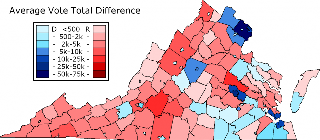
6. Democratic votes
The growth of Northern Virginia has been a significant factor in tipping Virginia from being a reliably conservative state to a swing state. Here Daily Kos maps the total difference in votes between the Democratic and Republican parties in the 2013 statewide elections:
7. Transplants
Northern Virginia is distinctive in part because its residents come from all over the country, drawn by jobs in the Federal government and its auxiliary industries. Military-dominated Hampton Roads is the only other region in Virginia that comes close in this regard. Particularly notable in Northern Virginia is the composition of those transplants. Virginia has been experiencing significant in-migration for decades, but in most of the state migrants are more likely to be from the Midwest or from other states in the South. In Northern Virginia, they are disproportionately more likely to have been born in the Northeast or West Coast, or to be international immigrants.


8. Catholics
Like the rest of the South, Virginia historically had a very low Catholic population. Its first Catholic parish in Alexandria wasn’t founded until 1795. The Anglican state’s few Catholics were more likely to be in the north, close to the originally Catholic colony of Maryland. Successive waves of immigration and conversion brought Baptists (who eventually came to dominate the South), Presbyterians, and United Methodists, but Catholics remained few and far between. With the post-WWII flood of migrants from the Northeast, however, Northern Virginia’s Catholic population suddenly boomed:

Because of this rapid growth in the number of Northern Virginia Catholics and the cultural gap between them and the state’s older Catholic population, a separate diocese was created for them. Initially, church leaders worried it was too small to be an effective diocese, but they were quickly proven wrong. Despite its smaller area and smaller overall population, the Diocese of Arlington now has double the Catholic population of the Diocese of Richmond.

Northern Virginia is the only significant area of the state where the largest Christian denomination is the Catholic Church – contrasted with the rest of the state, where Southern Baptists or United Methodists predominate.

9. You guys
No explanation needed on this map, which comes from Joshua Katz’s mapping of the Harvard Dialect Survey.

10. Nationals fans
Virginia is the largest state in the U.S. without a major league sports team and contains two of the six largest metro areas without one (Richmond and Hampton Roads). Various Washington, DC teams have attempted to capitalize on this, with the NFL’s Washington Redskins being perhaps the most successful. But overall, DC teams have struggled to capture Virginians’ loyalties. Virginia remains one of the largest neutral zones on fan maps, with the most popular team being whatever team is most popular nationwide. In baseball, that means the Yankees and Red Sox, with the Atlanta Braves coming in third across most of the state. Northern Virginia, however, is a noticeable zone of support for the Washington Nationals. Take a look at the New York Times’ map of MLB supporters (based on facebook likes):

Northern, but still Virginia
While Northern Virginia is distinct in many ways, it has also had a profound impact on the rest of the state. Many of Virginia’s most prominent natives, including George Washington and Robert E. Lee, came from the region. Northern Virginia’s connection to the Northeast corridor and the Federal government has helped Virginia to weather several economic downturns. The wealth of the DC suburbs has given Richmond a reliable source of tax revenue.
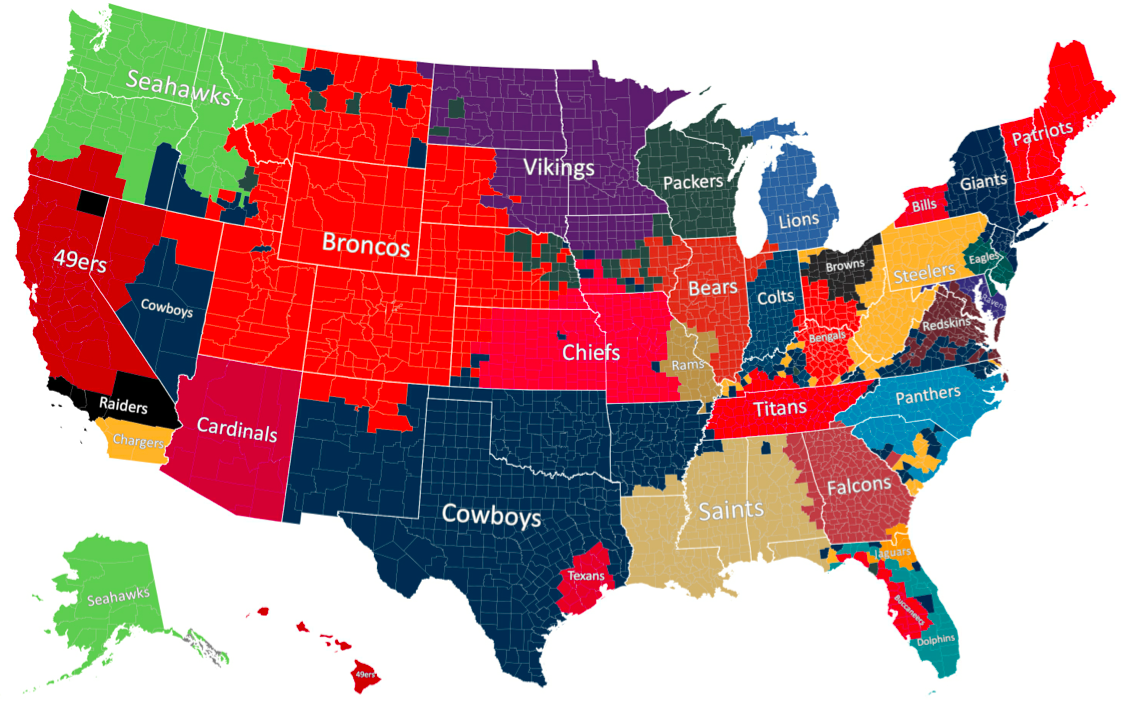
Colleges have been another point of connection. The NY Times’ fan map may not show much down-state enthusiasm for the Nationals, but its map of college football loyalties is much more telling. Northern Virginia’s strong school systems produce a small army of high school graduates, the vast majority of whom attend college in-state. They make up a significant share of students at all of Virginia’s public universities, where they have influenced and been influenced by the broader culture of the Commonwealth. Many have moved to other metro areas in Virginia after graduation or developed networks around the state. The role of public colleges in shaping state culture and building connections is a curious feature of contemporary America.

Migration data also shows a strong connection. The Northern Virginia counties have acted as a gateway to the rest of Virginia for immigrants foreign and domestic, who frequently retire or move further south after starting out in NoVA. Three of the last four governors of Virginia were born out of state and moved to Northern Virginia as children or young adults. Northern Virginia has also been a magnet for Virginia residents looking for advanced jobs, who find it easier to settle on the familiar side of the Potomac after moving to the DC area. While crossing the Rappahannock may feel a bit like entering a different state, crossing the Potomac is still the real transition.
